 |
 |

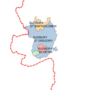
Our map shows Sudbury was included as part of Thingoe at the time of Domesday. This odd inclusion might have been made to compensate Thingoe for the reduction in taxable capacity when Bury St Edmunds was given some tax exemptions as part of its monastic grants in the 10th and early 11th centuries.
The red dashes are the line of the modern county boundary, and indicates that Sudbury in 1086 was considerably smaller than its modern boundaries.
Olof S Anderson described the areas of the Suffolk Hundreds as part of his monumental work on the "English Hundred-Names" and their Meeting Places, in 1934, and his entry for Thingoe was as follows:
O S Anderson wrote:
"A district mainly W. of Bury St Edmunds, E. of Risbridge, N. of Babergh and W. of Thedwestry hundreds, bounded on the north-east by the Lark, including in the north the parish of Lackford and in the south-east those of Nowton and Hawstead. Sudbury, now in Babergh hundred, originally belonged to this hundred." There followed these variously spelled name references:
pe half nigende hundredes sokne into Dinghowe 1042-66 (14) Thorpe 418, Tingohou, Tingohv, Tinchou, Chinhoge, Thingohov, Thingehov, Tingoov, Tingov; Tingoho 1086 DB, Tingehou 1086 (c. 1180) IE, Thinghoge 1087-98 (c. 1190) Bury, Tinghowe 1182 Samson f. 89, Tinghohdr' 1189, 1193 P, Thinghoghe c. 1190-1200 Bodl, Thinghog' 1220 Fees, Thyngho 1240 Ass 818 m 54d, Thingml'e 1254 Norwich, Thinghowe 1275 RH, 1316 FA, Tyngho 1275 RH, ~ . Thynghowe 1327 SR
The names are derived as follows: " -From Old Norse (ON) pinghaugr 'mound of assembly'; cf. lPN 87 f. Gage (op. cit. p. XI) locates the mound on Shirehouse Heath just N. of Bury St Edmunds and suggests that the exact spot may be a mound (marked on his map of the hundred), where a mill stood in his day. The mound is referred to as Thinghogo by Hermannus c. 1100 (MemStEdm I 31). Originally all the eight and a half hundreds of Bury St Edmunds apparently met here. For the later meeting-places of the liberty see above p. 83." This reference follows here:
P83 ;- "that (court) for the franchise of Bury St Edmunds seems to have been first held at the thing place that gave name to Thingoe hd (q. v.). ( Later the court of the franchise was held at Cattishall Green, E. of Bury St Edmunds (it is first mentioned in 1187: curia regis apud Catteshale extra Sanctum JEdmundum Bury 187; in the 13th century the Suffolk assizes were held at Ipswich and Cattishall), and after 1305 at Henhoghe on Shirehouse Heath just N. of the town; cf. J. Gage, Thingoe Hundred, London 1838, p. XI)."
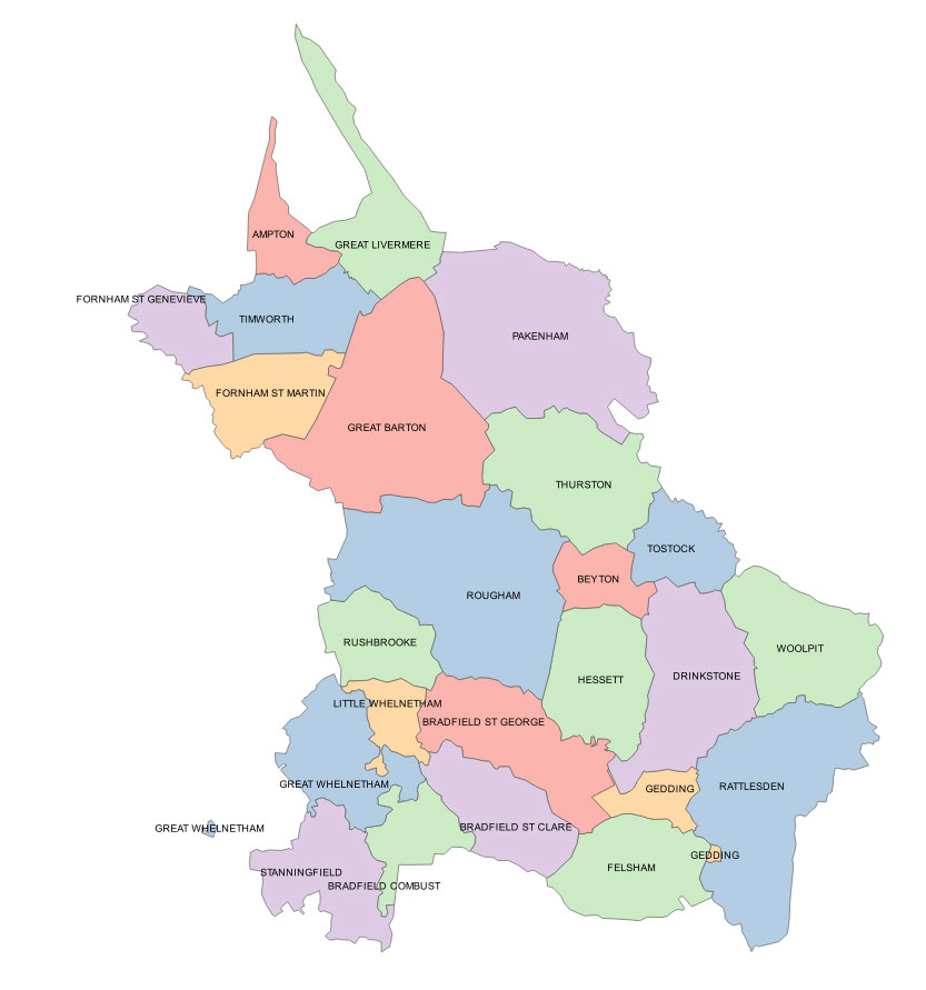
"E. of Thingoe hundred and N. of Babergh and Cosford hundreds, bounded by Blackbourn hd on the north, where it includes the parishes of Woolpit, Tostock, Thurston, Pakenham, Gt Livermere, Ampton, Timworth and Fornham St Genevieve. Its northern boundary has a curious shape with two long, narrow strips reaching up towards a place called Rymer Point, apparently a spot of some importance in early days, for the boundaries of all the parishes in a wide circle round it, nine in all, are made to meet there."
Name references:
"Theod Wardes Treo, Thewardestr(e)u, Thewardestre 1086 DB, Tedeuuartstreu, Teodeuuardes treou 1086 (c. 1180) lE, Theoduuardesthreo, TheowardestJ'e 1087-98 (c. 1190), Teodwardestre 1121-48 (15) Bury, Thedwarder;tre 1182 Samson f. 81, 1240 Ass 818 m 55, 1247 MemStEdm, 1254 Norwich, 1265 Mise, 1;~03, 1344 Ipm, Tedwardestrie 1199 P, Thedwarestre 1220 Fees, Thedwardistre 1316 FA, 1327 SR, 1360 Pat, Thedwarstre 1320 Tpm, Thedwastre 1539 Bodl. -OE *Peodweard pn and treo 'tree'; for the pn cf. the field-name Thiedwarescroft, Tedwardescroft (Chattisham Sf) AD II 195, 217.
The hundred-name survives in THEDWASTRE House and THEDWASTRE Hill Farm Thurston parish, c. 1/2 mile. East of Thurston station, on either side of the railway.
There follows this footnote:
"1 The entry on the Patent rolls quoted above contains that some persons named 'conspired at Thurston on Monday after Michaelmas ... that (one of them) would act so that no execution of right by plaint or otherwise should be done in the abbot of Bury St. Edmunds's hundred of Thedwardistre'. This may be taken to show that the hundred-court was then actually held at this place."
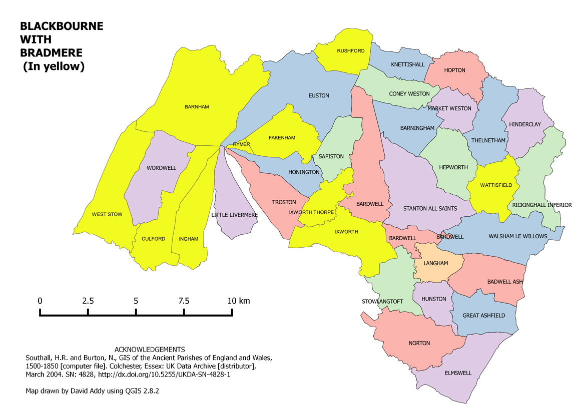
"On the Norfolk border, N. of Thedwestry and Thingoe hundreds and East of Lackford hd, including in the west the pars of Barnham and West Stow.
In Domesday this hundred was divided into two hundreds, Blackbourn hd and Brademera hund', also mentioned as Brademere Hundret 1087-98 (c. 1190) Bury. (A footnote reads:-"2 In the Pinchbeck Register I 328 (MS c. 1333) Brademer is written in the margin against a list of the vills of Blackbourn hd."
No definite boundary between the two hundreds can be evolved out of the Domesday entries, but for those parishes assigned to Bradmere in Little Domesday 1086, they are shown here in yellow.
In the Feudal Book of Abbot Baldwin (Bury p. 7) only the manors of Ingham, Culford and West Stow in the SW. part of the present hundred are assigned to Brademere, the remaining parishes of the modern hundred being assigned to Blackbourn hd.
-The name is from Old English, (OE) brad and mere 'large pool'. It has been suggested that the name is preserved in BROAD MERE in Troston par, c. 1 m. N. of Troston, which presupposes, however, that the hundred was once of considerably wider extent than in 1086.
-No mention of the hd of Brademere has been found after the 11th century. It was apparently completely merged in Blackbourn hd, which accordingly appears as a double hundred in the 12th century: Blacbruna -e, Blachebruna -e, Bla(c)kebrune 1086 DB,' Blac(h)ebrune 1087-98 (e. 1190), Blakebourne 1121 -48 (15) Bury, (in) duobus hundred' de Blakebrun' 1182 Samson f. 92d, 1220 Fees, Blakebrunnehundredum Sancti AEdmundi 1185, (de) II hundredis 2 de Blakebrunnehundredo 1188 P, Blakebrunne 1219 Fees, Hllndr' de BlacbTllnne (23 jurors) 1240 Ass 818 m 55, Blakeburn' (respondet per duobus hundr') 1275 RH, Blakebllrne 1316 FA, Blakebourne 1327 SR.
Old English -OE blaec and burna 'black stream'. The name is probably, as suggested by Powell, ( E. Powell, A Suffolk Hundred in 1283, Cambridge 1910, p. XVIII.) preserved in BLACKBURN Farm in Stanton parish (1 m. N. of Stanton; to judge from the map the nearest stream is now a mile away, but on the old 1" map a small stream is marked running past Blackburn House). In modern times the hundred met at Stanton." (in the Cock Inn).
O S Anderson wrote:
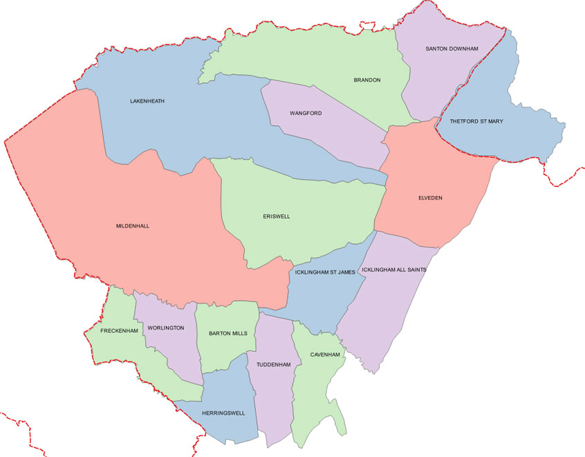
"Consists of the NW. corner of the county, N. of Risbridge and west of Thingoe and Blackbourn hds, from which it is separated by the Icknield Way.
Lacforda -e, Lacheforda, Leac;orde H' 1086 DB, Lecforde -a hundr' 1086 (c. 1180) lE, Leacforde Hundret 1087-98 (c, 1190) Bury, Lacford hdr' 1168 P, Hundredum de Laford' 1185 Rot Dom, Lacford' 1226-8 Fees, llundr' de Lacford 1240 Ass 818 m 56, 1265 Mise, 1275 RH, 1303 FA, 1327 SR, Lackford 1316 FA.
The hundred is apparently named from the ford still in existence below LACKFORD BRIDGE (del Punt of Lacford 1301 Cl), where the Icknield Way crosses the river Lark.
The vill of LACKFORD, in Thingoe hd, c. I m. SE. of Lackford Bridge, is named from the same ford: Lecforde, Lacforde 1045-98 (11) EHR 43, 382 f., Le(a)cfordam 1086 DB, Leacforde 1087--'-98 (c. 1190) Bury, Lacford' 1204 Obl (p), 1250 Cl, Lacford 1215 FF, 1253 Ch, Lakeford 1248 Pat. The first clause of the name goes back on an OE base in -(E-or -ea-, as indicated by the 11th century forms in -eo, -ea-; second et OE forde.
A footnote reads, "1 Professor Ekwall now wishes to withdraw the suggestion for the etymology of the name made in ERN 236. In his opinion, the first element is OE leae 'garlic'. This word is generally assumed to have become lee by smoothing in all Anglian dialects, but there is nothing to prove that this was the case in Suffolk. A PN like Yaxley may indicate that ea was preserved here."
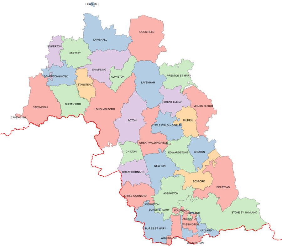
O S Anderson wrote:
"A comparatively large district in the south of the county on the Stour. W. of Samford and Cosford hds, including in the east the pars of Stoke by Nayland, Polstead, Boxford, Groton, Monks Eleigh and Preston, in the north, bordering on Thedwestry and Thingoe hds, those of Cockfield, Lawshall and Hartest, and in the west, bordering on Risbridge hd, those of Somerton, Boxted and Cavendish. It ranked as a double hundred. Like the following hundreds it belonged to the franchise of Bury St Edmunds.
Babenberga duo hund', B.binberfjlJ, duo W, Banberca dvo H' (1), Baberga dro H' 1086 DB, Babenfjbei (Babengb'ei Hamilton) hundr' 1086 (c. 1180) lE, (in) Basbenberge duobus hundretis 1087-98 (c. 1190) Bury, Babbenbergahdr' 1166, 11 hundr' Babenberga 1168, Babinbergehclr' 1170 P, Babenberg' 1182 Samson f. 101d, (de) Jl hundredis de Babenberga 1189, 1193, Babbingebergahundredum 1193 P, Babbeberg' 12]9, (in) duobus hundredis de Badberee 1220 Fees, Babbergh' 1226--8 Fees, 1275 RH, Babberghe 1240 Ass 818 m 54, Babenb' 1250 Ass 819 m 2d, Badberewe 1275 RH, Babberge 1316 FA, 1327 SR, Badbere 1346 FA, Babberwe 1355 lpm, Babber 1535 VE.
--The hundred meeting-place was no doubt on BABERGH HEATH (Balberg' (sic) heath 1304 AD n 532, Balberte 1311 AD Ill, Barbary Heath (Old 1" OS map) between Acton, Chilton and Gt Waldingfield, from which it takes its name. (Babergh Hall and Place and Babergh Heath Fm (6") are on the modern map, c. 1 m. W. of Gt Waldingfield.)
-From OE Babba pn (Redin 83) and be(o)rg 'mound' (cf. Barrow Hill in Aeton?). Cf. BAYTHORN Ess, C. 10 m. to the west: Babbingperne c. 958 (14) BCS 1012; further Karlstrom 125.
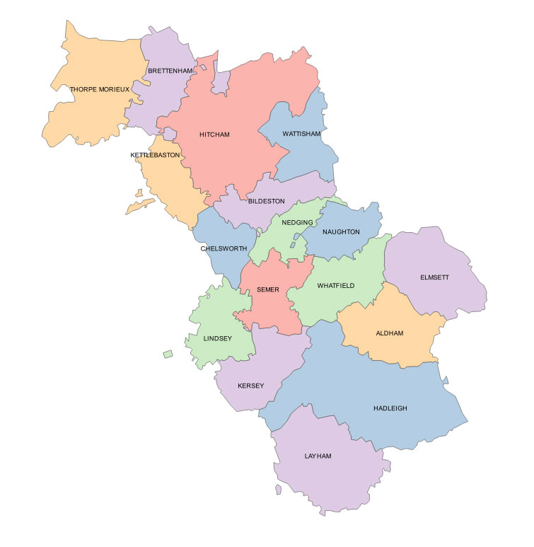
"W. of Samford hd, N. and E. of Babergh hd on the river Bret, including in the north, bordering on Thedwestry hd, the pars of Hitcham, Brettenham and Thorpe Morieux. It counted as a half-hundred.
Dim' H' de Costort, Costorda; Corstorde Dim' h', Dim' H' de Crostort 1086 DB, Corsforda, Crostorda dimidium hundr' 1086 (c. 1180) IE, (in) dimidio hundredo de Corstorde 1087-98 (e. 1190), Costord 1148---56 (14) Bury, Corestorde hundr' 1182 Samson f. 101, Cosfordhundredurn 1191, dim. hundredum de Costeld 1195 P, Costord' 1219, dimidium hundredum de Corstord' 1220 Fees, de Corstord 1210 Ass 818 m 55, 1265 Mise (half hd of), 1275 RH, 1286 Ass 829 m 33, Corstorde 1327 SR, Costord 1346 FA. -The hundred is named from a ford over the Bret at COSFORD BRIDGE (6"), 1 1/ 2 m. NW. of Hadleigh: Corstorde 1087-98 (c. 1190) Bury, Cost' 1205, Corstord' 1206 Cur, (eheminum quod tendit versus) Corstord Hy3 Mon VI 592, Corstord (Mill) 13 AD Il 209, Costord 1340 Ch, 1398 BM.
-The first element is very likely an old name of the Bret, derived from the British word for 'reed, bog' found in W COl'S; v. ERN 95. Second el. OE ford."
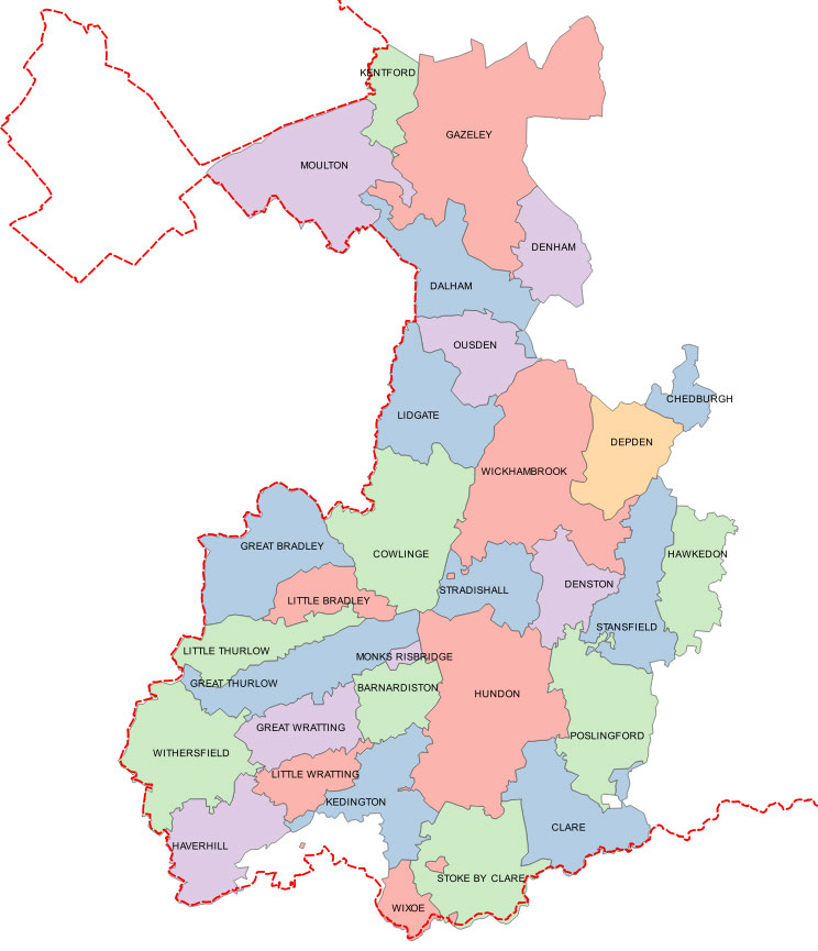
O S Anderson wrote:
" In the SW. corner of the county, W. of Babergh and Thingoe hds, including in the north the pars of Moulton, Kentford, Gazeley and Higham and in the east those of Denham, Ousden, Depden, Chedbnrgh, Hawkedon, Poslingford and Clare.
Risebruge 1086 DB, Risebrigge 1087-98 (c. 1190) Bury, 1240 Ass 818 m 54d, Risebrigehundredum 1188, Risebriggehdr' 1189 P, Risebreg' 1219, Risebrug' 1220 Fees, Rysebreg 1265 ~iisc, Risebregg' 1275 RH, Risebreg 1280 Pinchbeck II 273, Rissebrig, Resebreg 1287 Ipm, Rysebrege 1316 FA, Rysebregge 1327 SR Risshebreg' 137-1 SR 180/28.
-In the NE. corner of Barnardiston par, there is a small district (measuring 129 acres), according to Bartholomew 'an uninhabited parish', called MONKS RISBRIDGE (marked on the 6", 1" (not popular ed.) and OS Index maps). Very likely the hundred is named from the bridge that gave name to this district. There is now no river near it, but on his large map of Suffolk (1826?) Greenwood marks a small stream in its southern boundary.
-From OE hr'is or *hr'isen 'of brushwood' and brycg; 'bridge built of brushwood', perhaps over the stream just mentioned. Cf. PNW0 22, PNSx 258."
| Go to Maps homepage | Go to Domesday Book Homepage | Go to QGIS digital mapping Homepage |
Page created 7th June 2015 Last updated on 11th June, 2020 | Go to Main Home Page |