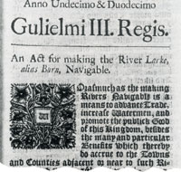
The Navigation Act 1700 |
The River Lark
Assessment by Joseph Priestley 1831
LARKE RIVER.
11 & 12 William III. Cap. 22, Royal Assent 11th April, 1700.
57 George IlL Cap. 71, Royal Assent 10th July, 1817.
THE navigation of the River Larke or Burn extends for the distance of about fourteen miles from a place called Long Common, a little below Milden Hall Mill, to Eastgate Bridge in
Eastgate Street Bury St. Edmunds, in the county of Suffolk; its level from its situation in the flat part of the county is in no part greatly above the tideway.
The first step towards the rendering this river navigable, was an act of parliament in the year 1700, bearing as title, 'An Act for making the River Larke, alias Burn, navigable.' By this act power was granted to Henry Ashley, Esq. of Eaton Socon, in Bedfordshire, his heirs and assigns, to cleanse, enlarge or straighten the said river, and to construct all necessary works on the same. He was empowered to demand certain rates, and a number of commissioners were appointed to settle disputes, which commissioners were from time to time to elect others on vacancies. After the lapse of several years, the property became vested in Mrs. Susanna Palmer, and great inconvenience arose from the neglect of the commissioners in not filling up vacancies. A second act was therefore obtained in 1817, entitled, 'An Act for amending and rendering more effectual an Act of his late Majesty, King William the Third, for making the River Larke, alias Burn, navigable;' by which new commissioners were appointed with the necessary powers, and the following determined upon to be paid to Mrs. Palmer, in lieu of former tolls as
TONNAGE RATES.
- For Coals, by Lynn Measure 4s 2d per Chaldron.
- For Deals 2s 7½d per Half Hundred.
- For Timber (accounting Forty Feet to the Load) 2s 7½d per Load.
- For Wool, (accounting Ten Tod to the Pack) 3s 3½d per Eight Packs.
- For Salt 3s 3½d per Weigh.
- For Wheat or Barley, (reckoning Ten Coombs to the Load) 2s 7½d per Load.
- For Oats 3s 3½d per Last.
- For Beans or Peas, (reckoning Ten Coombs to the Load) 3s 3½d per Load.
- For Grocery Wares or Commodities 3s 3½d per Ton.
- For Oil or Wine 5s 0½d ditto.
- For Turf 4s 2d per Thousand.
- For Reed, Sedge, or Hay, (reckoning Twenty Hundred Weight to a Load) 4s 2d per Load.
- For Hemp, (reckoning Twenty Hundred Weight to a Load) 4s 2d per ditto.
- For Malt 3s 3½d per Last..
- For Bricks, (reckoning Five Hundred to the Load) 2s 7½d per Load.
- For Tiles 2s 11d per Thousand.
- For all other Goods, Wares, Merchandize or Commodities whatsoever 2s 7½d per Ton.
All these Rates to be considered as payable for Goods passing between the Sluice next above Milden Hall Bridge and Bury St. Edmunds, and in Proportion for a greater or less Weight and for a less Distance; and the Proprietor may lower or raise all or any Part of the said Tolls from time to time. And the Commissioners are empowered to raise the Tolls for the Payment of Expenses incurred by making new Works, application being made to them by the Proprietor for that Purpose.
This is a very useful navigation, and beneficial to the agriculturists of the district about Bury, as besides the advantageous mode it affords of conveying their produce down to Lynn, by its junction with the Ouse near Littleport, it conveys to them in return, and at a much lower rate than by land carriage, fuel and other articles of home consumption which their own neighbourhood cannot supply.
|
SOURCE:
Taken from the book, "Historical Account of the Navigable Rivers, Canals, and Railways, of Great Britain", by Joseph Priestley, published in April 1831.
Later re-published as "Priestley's Navigable Rivers and Canals".
|

