Babwell Clough, or the Old Clough
Seen in 1971, this was the view upstream to the Sugar Beet Factory
Just around the bend on the right was the 1715 Cut to Fornham Wharf |

Babwell Clough and David Addy
Seen in 1971, this was the view downstream to the remains of structure. Past the brickwork, on the right, is the junction with the diverted stream from the former Mermaid Pits. |

Mill Farm, Fornham St Martin, c 1972
This derelict farm was formerly the Fornham Water Mill. It was soon to be demolished to make way for a golf clubhouse. |

Mill Farm, showing the cattle bridge in 1972
This bridge allowed cattle to be moved over the lock chamber to cross the river. |

Mill Farm, Millstream outlet seen in 1972
This brickwork was part of water management just below the lock at the Fornham Water Mill. |

View downstream to new footbridge in 1976.
Built for the Lark Valley Country Club golf course |

View downstream to Fornham Lock.
May also have been called the Causeway Lock.
The white railings mark the road bridge built to replace the old wooden Causeway Bridge. Modern maps call this Sheepwash bridge today. |

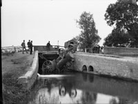
Causeway Bridge Tragedy 1890. This view of the old wooden bridge is looking upstream. Just beyond the bridge would be the site of Fornham Lock. Note the water flowing in from the left, and the brick channels for water management on the right. |

View of derelict Ducksluice Farm c 1998. |

View upstream to the site of Ducksluice Lock.
The footbridge nowadays carries the Lark Valley Walk from one bank to the other. |

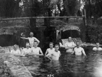
Soldiers enjoy a dip at Ducksluice at Fornham St Genevieve.
This view was taken by Walton Burrell in August, 1915 |

Another view of soldiers at Duck sluice at Fornham St Genevieve by Walton Burrell, dated 13 August 1915. |

A view of local men at Ducksluice at Fornham St Genevieve.
This view was taken by Walton Burrell in 1916 |

View upstream to the site of Hengrave Lock. These remains of a former lock are viewed from a footbridge over the river, which was formerly open to vehicles in the 1990s. TL 831 690 |

View of site of Hengrave Lock, downstream of the last picture. Marked on the OS map as a weir at TL 830 693. |


